By Thomas Furey (Marine Institute)
It is essential that we improve our understanding of the connectivity between the depth and shape of the seabed, the seafloor sediment composition and benthic habitats, and the oceanographic influences on this ocean bottom environment. This will support our ability to monitor and adapt to change, deliver more sustainable marine resource management, and reduce risk to the Atlantic Ocean and its coastal regions and inhabitants.
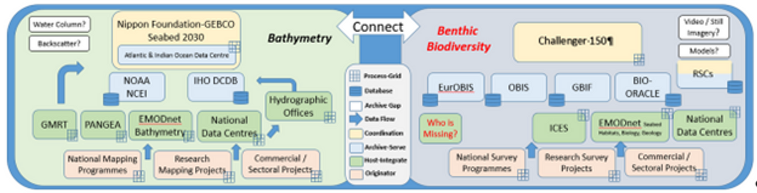
To guide future bathymetry and benthic habitat data gathering initiatives and ensure that meaningful and comparable scientific data are acquired in our offshore environment, the MISSION ATLANTIC Work Package 4 team on “Benthic Mapping: Ecosystem, Resources, and Pressures” developed and published Deliverable 4.1, a “Strategic Framework for Atlantic Bathymetry and Benthic Habitat Mapping for IEA.
Strategically acquired systematic bathymetry mapping will enable high-resolution habitat suitability modelling, which is to say the prediction of sensitive habitat distribution based on seabed terrain-derived characteristics, and oceanographic and climate modelling information.
The Atlantic mapping framework identifies the policy drivers and scientific and socioeconomic rationale for mapping. It provides an overview of the Atlantic bathymetry and benthic mapping landscape and key initiatives, programmes and organisations. It assesses the operational and data networks, initiatives and approaches, and captures standards and best practices, as well as approaches to survey planning and prioritization. The report will be a valuable asset in knowledge exchange between the bathymetry and benthic mapping communities, and inform the Atlantic mapping roadmap to guide future efforts, activities, and resource allocation.
Read the full deliverable report 'D4.1 - Strategic Framework for Atlantic Bathymetry & Benthic Habitat Mapping for IEA' here.